Distance: ~6 miles
Elevation Gain: 1,100' (Moderately Strenuous)
Est. Time: ~5 hours (including a lunch stop)
Parking: $10 (bring exact cash!)
Important points to note:
* Restrooms and a water fountain are available at the trailhead.
* Dogs are not permitted at this park.
* Cell phone service is marginal to non-existent at the trailhead and on trails.
* A pit toilet is available at the Castle Rock Trail Camp.
Description:
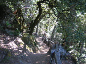
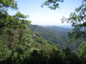
Castle Rock State Park is a land of sculpted sandstone, lush forests, and sweeping vistas. From one of the highest ridges in the Santa Cruz Mountains, park visitors enjoy hiking, backpacking, and horseback riding. Rock climbers explore the park's caverns and rocks, including the namesake Castle Rock. Plant-lovers come for California black oaks, knobcone pines, and high-elevation coast redwoods. The park's 34 miles of rugged trails conveniently connect to an extensive trail system that links the Santa Clara and San Lorenzo valleys to nearby Big Basin Redwoods State Park and open space preserves on the Skyline to the Sea Trail.
For more information about Castle Rock State Park, visit the park's web site: https://www.parks.ca.gov/?
You can download a brochure with a trail map from: https://www.parks.ca.gov/
Carpooling is strongly encouraged, due to limited parking at the trailhead. You can go to https://www.groupcarpool.com/
Route:
We'll first hike over to the overflow parking lot, and then hike ~0.5 miles along the Saratoga Gap Trail. At the intersection, stay to the left and continue along the Saratoga Gap Trail. Hike along this trail for another ~2 miles, to the Castle Rock Trail Camp. We might stop for lunch at that trail camp, or wait for later to have lunch. For the return portion of the hike, stay to the left at the intersection and hike up the Ridge Trail, via Goat Rock. When the Ridge Trail terminates at the Saratoga Gap Trail, turn left and follow the Saratoga Gap Trail all the way back to the trailhead.
We'll do an optional ~1 mile extension at the end, along the Castle Rock loop just south of the park entrance.
The http://redwoodhikes.com/
Warning: This is a moderately strenuous hike. Please be sure that you are comfortable with this level of effort before joining us.
What to Bring:
Start your day with a hearty breakfast. Bring water (at least 2 litres per person), lunch, snacks, hat, windbreaker, and multiple layers of clothing. Sunblock and sunglasses are advisable. Bring $10 cash, to pay for parking.
ALERT: Poison oak grows beside some of these trails. Be advised to wear long trousers, and stay on the trails.
Where we will meet:
We will meet in the main parking lot at the park entrance (on the west side of highway 35, ~2.5 miles south of the intersection with highway 9): https://maps.app.goo.gl/
If the main parking lot is full, you might find some empty spaces in the overflow parking lot ~0.2 miles south of the main parking lot along highway 35 (and on also the west side): https://maps.app.goo.gl/
As a last resort, you might find spaces at the Summit Rock Parking lot (~1 mile north of the main parking lot along highway 35, and on the east side): https://maps.app.goo.gl/
Rain/Weather policy:
If there's any ambiguity about the weather on the day of the hike, check the forecast on the morning of the hike.
If it's raining significantly, the hike is cancelled. If the weather is ambiguous, we will send out an email to the registered participants on the
morning of the hike.
Disclaimers:
Joining any hike is entirely voluntary and participants assume any and all risks associated with the activities. By registering or attending this event, participants agree to the conditions posted at:
http://northerncalifornia.alum
Event Disclaimer:
Because this event is in person, you acknowledge the below by coming to this event.
I acknowledge and understand that: (i) I am not required to participate in this event; (ii) my participation is voluntary and at my sole risk; and (iii) I am responsible for my own protection against Covid-19, including, without limitation, following all health and safety protocols communicated to me or posted at the event venue.
Date and Time
Saturday, October 28, 2023
9:30 AM - 2:30 PM PT
Primary Contact
John Keen
John.keen@alum.mit.edu